Recent Projects and News

Blog Post – Drone Service Solutions

Blog Post – Drone Service Solutions

Blog Post – Drone Service Solutions

In today’s rapidly evolving agricultural landscape, the integration of drone technology is revolutionizing the way we manage and optimize our land resources. SAS Land Services Ltd, a trusted agricultural contractor and drone service provider, is at the forefront of this transformation, offering a comprehensive suite of drone services tailored to meet the diverse needs of the agricultural industry. From multispectral mapping to precision spreading and spraying, their CAA-approved operations ensure the highest safety standards and efficiency. Beyond their core services, they extend their expertise through consultancy and training, empowering new entrepreneurs to successfully launch their own drone-based businesses. With a strong presence in Berkshire and a commitment to client satisfaction, SAS Land Services Ltd is your go-to partner for innovative and cost-effective drone solutions.
Drone Service Solutions Overview

SAS Land Services Ltd offers a comprehensive range of drone services tailored for agricultural and horticultural applications. Let’s explore the key solutions that are transforming land management and crop optimization.

Agricultural and Horticultural Applications

Drones have revolutionized agriculture by providing farmers with precise, real-time data about their crops and land. These aerial tools offer a bird’s-eye view of fields, allowing for more efficient resource management and decision-making.

One of the primary applications is crop monitoring. Drones equipped with high-resolution cameras can detect issues such as pest infestations, nutrient deficiencies, or irrigation problems before they become visible to the naked eye. This early detection capability enables farmers to take prompt action, potentially saving entire harvests.

Another crucial application is yield estimation. By analyzing drone-captured imagery, farmers can predict crop yields with remarkable accuracy, helping them plan harvesting schedules and manage their supply chain more effectively.

Multispectral Drone Mapping Benefits

Multispectral drone mapping is a game-changing technology in precision agriculture. This advanced technique uses specialized sensors to capture data across multiple spectral bands, revealing information invisible to the human eye.

The primary benefit of multispectral mapping is its ability to assess crop health. By analyzing the reflected light from plants, farmers can identify stressed areas, nutrient deficiencies, or disease outbreaks with pinpoint accuracy. This level of detail allows for targeted interventions, reducing the need for blanket treatments and minimizing environmental impact.

Moreover, multispectral mapping aids in optimizing irrigation. By detecting variations in plant water content, farmers can adjust their watering schedules and methods, leading to significant water conservation and improved crop yields.

Drone Spreading and Spraying Techniques

Drone-based spreading and spraying offer precision and efficiency unmatched by traditional methods. These techniques allow for targeted application of fertilizers, pesticides, and other treatments, reducing waste and minimizing environmental impact.

One of the key advantages is the ability to treat hard-to-reach areas. Drones can easily navigate challenging terrains or dense crops where ground-based equipment might struggle. This capability ensures more uniform coverage and reduces the risk of missed spots.

Furthermore, drone spraying can be highly automated. Using pre-programmed flight paths and real-time sensors, drones can adjust their application rates on the fly, ensuring optimal coverage even in variable conditions. This level of precision not only improves efficacy but also significantly reduces chemical usage.

Specialized Drone Cleaning Services

Beyond agricultural applications, SAS Land Services Ltd leverages drone technology for innovative cleaning solutions. These services address unique challenges in greenhouse and solar panel maintenance.

Efficient Greenhouse Cleaning Methods

Greenhouse cleaning is a critical yet challenging task in horticulture. Drones offer a safe and efficient solution to this problem, reaching areas that are difficult or dangerous for human workers to access.

The process begins with a thorough inspection using high-resolution cameras. Drones can identify areas of dirt accumulation, algae growth, or structural issues that need attention. This initial survey allows for targeted cleaning efforts.

Next, specialized drones equipped with cleaning attachments can apply cleaning solutions and scrub surfaces without risking damage to delicate greenhouse structures. This method not only saves time but also ensures a more thorough clean, promoting better light transmission and plant health.

Solar Panel Cleaning with Drones

Solar panel efficiency is highly dependent on cleanliness, but manual cleaning can be risky and time-consuming. Drone-based cleaning offers a safe and cost-effective alternative.

The process starts with a drone survey to assess the condition of the solar array. Using thermal imaging, drones can identify hot spots or underperforming panels that may require special attention.

Cleaning drones then use a combination of air pressure and soft brushes to remove dust, pollen, and bird droppings without scratching the panels. This gentle yet effective method can significantly improve solar panel efficiency, often restoring output to near-original levels.

Land Management and Maintenance

Effective land management is crucial for both agricultural productivity and environmental conservation. SAS Land Services Ltd offers comprehensive solutions to address these complex needs.

Comprehensive Land and Scrub Management

Land and scrub management involves maintaining a delicate balance between agricultural productivity and ecological preservation. Drones play a pivotal role in this process by providing accurate, up-to-date information about land conditions.

Using high-resolution imagery and multispectral data, drones can identify areas of invasive species growth, soil erosion, or declining vegetation health. This information allows land managers to develop targeted intervention strategies.

Moreover, drones can assist in monitoring the effectiveness of management practices over time. By comparing historical and current data, managers can assess the impact of their interventions and make data-driven decisions for future land use.

Excavation and Grounds Maintenance Solutions

Excavation and grounds maintenance require precision planning and execution. Drones offer valuable support in these areas, enhancing efficiency and reducing environmental impact.

For excavation projects, drones can create accurate 3D models of the terrain, helping planners optimize dig sites and calculate exact volumes of material to be moved. This precision reduces fuel consumption and minimizes unnecessary disturbance to the surrounding area.

In grounds maintenance, drones equipped with multispectral cameras can identify areas of stress in lawns or landscaped areas before visible signs appear. This early detection allows for prompt intervention, potentially saving water and reducing the need for chemical treatments.

Agricultural Drone Business Setup

For those looking to enter the agricultural drone industry, SAS Land Services Ltd offers comprehensive support and guidance. Their expertise can help new entrepreneurs navigate the complexities of this emerging field.

Consultancy and Training Services

Starting an agricultural drone business requires a blend of technical knowledge, regulatory compliance, and business acumen. SAS Land Services Ltd’s consultancy services address all these aspects, providing a solid foundation for success.

The consultancy process begins with a thorough assessment of the client’s goals and resources. Based on this evaluation, SAS experts provide tailored advice on equipment selection, service offerings, and market positioning.

Training services cover both technical and operational aspects. Clients learn not only how to operate drones effectively but also how to interpret and apply the data collected. This comprehensive approach ensures that new businesses can deliver value to their customers from day one.

Spray Drone Business Packages

For those specifically interested in agricultural spraying, SAS Land Services Ltd offers specialized business setup packages. These all-in-one solutions provide everything needed to launch a successful spray drone operation.

The packages typically include:

  • CAA-approved spray drones

  • Comprehensive training on operation and maintenance

  • Guidance on regulatory compliance and licensing

  • Business planning and marketing support

By offering these turnkey solutions, SAS Land Services Ltd helps new entrepreneurs overcome the initial hurdles of entering the market, accelerating their path to profitability.

Safety and Standards Assurance

In the drone industry, safety and regulatory compliance are paramount. SAS Land Services Ltd prioritizes these aspects in all their operations and services.

CAA Approval and Compliance

Operating drones commercially in the UK requires approval from the Civil Aviation Authority (CAA). SAS Land Services Ltd has obtained and maintains this crucial certification, ensuring their operations meet the highest safety standards.

The CAA approval process involves rigorous assessment of operational procedures, safety protocols, and pilot competency. By meeting these stringent requirements, SAS demonstrates their commitment to safe and responsible drone operations.

For clients and business partners, this approval provides assurance that all services are delivered in full compliance with UK aviation regulations. It also enables SAS to operate in a wider range of environments and situations, expanding the scope of services they can offer.

Ensuring High Standards in Operations

Beyond regulatory compliance, SAS Land Services Ltd maintains high internal standards for all their operations. This commitment to quality ensures consistent, reliable service delivery.

Key aspects of their quality assurance process include:

  • Regular equipment maintenance and calibration

  • Ongoing training and skill development for all operators

  • Strict adherence to safety protocols in all operations

  • Continuous monitoring and improvement of service delivery

By maintaining these high standards, SAS not only ensures the safety of their operations but also delivers superior results for their clients. This dedication to quality has helped establish their reputation as a trusted leader in the agricultural drone industry.

Client Testimonials and Service Areas

The true measure of a service provider’s quality is the satisfaction of their clients. SAS Land Services Ltd has built a strong reputation based on positive feedback and a commitment to serving a wide geographical area.

Exceptional Service and Pricing

Client testimonials consistently highlight SAS Land Services Ltd’s commitment to excellence and value. Feedback often emphasizes the company’s professionalism, technical expertise, and ability to deliver results that exceed expectations.

One satisfied client stated:

“SAS Land Services transformed our approach to crop management. Their drone services provided insights we never had before, and at a price point that made sense for our operation.”

Another client praised their responsiveness and flexibility:

“What impressed us most was how quickly SAS could adapt to our specific needs. They weren’t just service providers; they became valuable partners in our agricultural operations.”

These testimonials reflect SAS’s commitment to not just meeting, but exceeding client expectations while maintaining competitive pricing.

Regional Coverage and Project Travel

While based in Berkshire, SAS Land Services Ltd extends its reach to serve a wide area, including Windsor, Bracknell, Ascot, and surrounding regions. This broad coverage ensures that clients across a significant portion of southern England can benefit from their expertise.

For larger projects, SAS is willing to travel beyond their usual service area. This flexibility allows them to take on significant contracts and serve clients with multiple locations or extensive land holdings.

Their willingness to travel demonstrates SAS’s commitment to meeting client needs, regardless of location. It also speaks to their confidence in delivering value that justifies the additional travel costs for larger projects.

How to Get Started

Engaging with SAS Land Services Ltd is a straightforward process designed to address your specific needs efficiently. Here’s how you can begin leveraging their expertise for your agricultural or land management projects.

Contact for Quotes and Information

Reaching out to SAS Land Services Ltd is the first step towards transforming your agricultural operations or launching your drone business. Their team is ready to provide detailed information and customized quotes based on your specific requirements.

To get started, you can:

  1. Visit their website and fill out the contact form

  2. Call their dedicated customer service line

  3. Send an email detailing your project or inquiry

When contacting SAS, it’s helpful to provide some basic information about your needs, such as the size of your land, the type of crops you’re growing, or the specific drone services you’re interested in. This allows their team to prepare a more accurate and tailored response.

Engage with Our Expert Team

Once you’ve made initial contact, SAS Land Services Ltd’s expert team will guide you through the next steps. They pride themselves on their consultative approach, ensuring that you receive solutions that truly address your unique challenges.

The engagement process typically involves:

  1. An initial consultation to discuss your needs in detail

  2. A site visit or virtual assessment of your property

  3. Development of a customized service proposal

  4. A follow-up discussion to refine the plan and address any questions

Throughout this process, you’ll have the opportunity to tap into the extensive knowledge of SAS’s experienced professionals. They can provide insights into best practices, emerging technologies, and innovative approaches that can benefit your operations.

Don’t hesitate to ask questions or seek clarification at any point. The team at SAS Land Services Ltd is committed to ensuring you have all the information needed to make informed decisions about your agricultural drone services or business setup.

Fertilising Biomass Willow Trees By Drone

Since gaining our CAA authorisation for large agricultural drone operations within the Uk our project base has been widespread and very varied, one such project which was a first for us as a company ( we never imagined we’d be tasked to fertilising trees by drone!) was to apply fertiliser to a plantation of biomass willow crop in Harrogate, North Yorkshire. The farm previously had a team of manual workers taking the fertiliser up the rows using buckets and wheelbarrows and spreading manually, a very labour intensive and time consuming process taking the team around 6-8 weeks to complete the area.

We flew the area with our DJI Agras T50 spreading drone with the broadcaster fitted and applied a granular 20-10-10 fertiliser at 750kg/ha, a huge rate with just a 50kg tank but all the same very achievable with the drone team completing the whole operation in just over 3 hours.

The drone has proved to be a much faster, efficient and more accurate way to apply the fertiliser, especially with the RTK GPS guidance on the drone giving cm level accuracy.

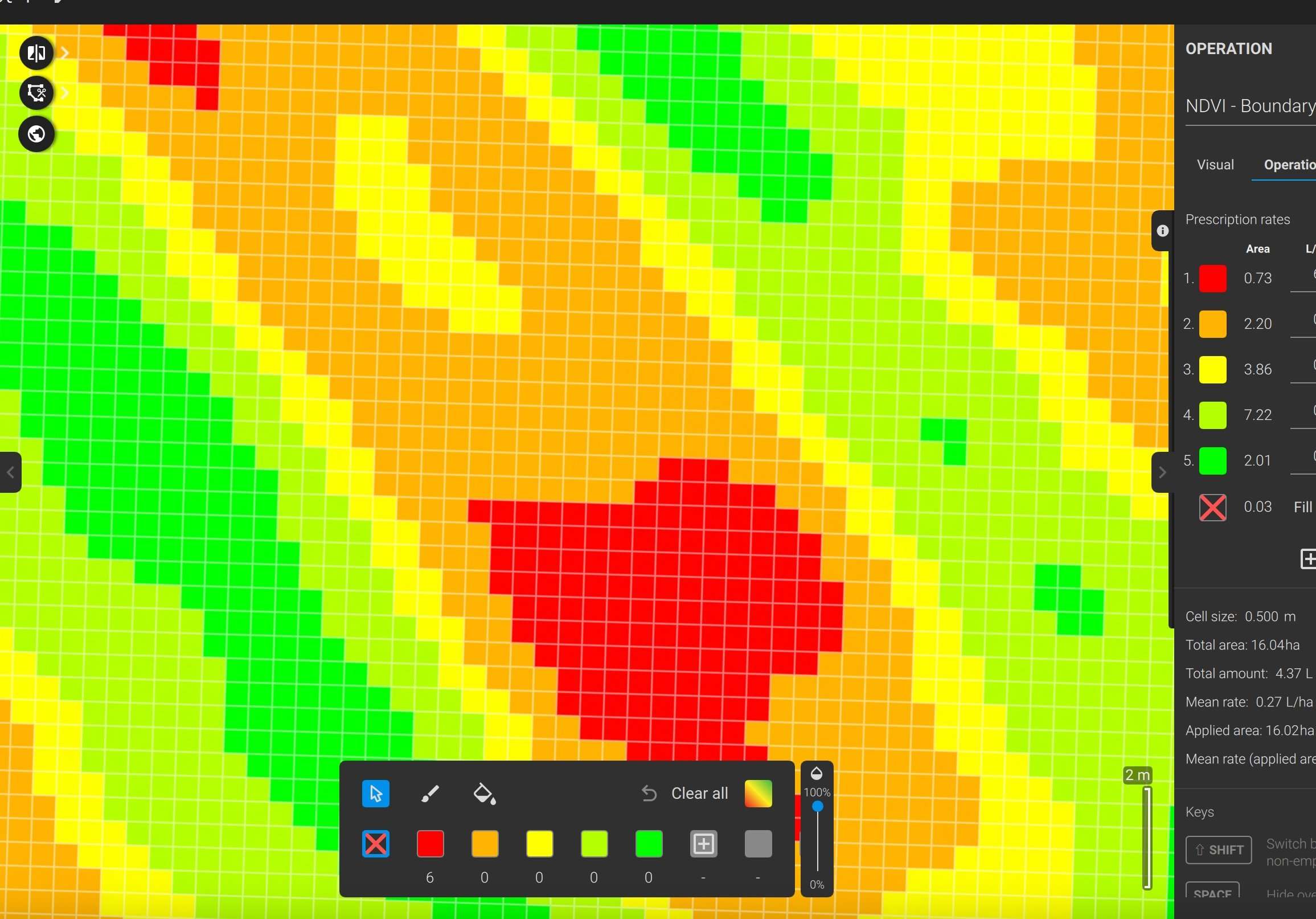
The drone also has the ability to apply fertiliser mr seed using variable rate technology, adjusting its output rate according to a prescription map, all which we can create.

Fertilising trees using a drone

By using the drone it has also increased the safety of the whole process, eliminating the need for manual workers to push heavy wheelbarrow over rough and sometimes steep terrain, helping growers meet health and safety requirements, as well as saving money on labour.

We offer fertiliser spreading or spraying across the UK whether that be fertilising trees by drone, or drone fertiliser spreading over any type of farmland or amenity grounds.

Take a look at our Instagram page for more pictures and details of other projects we’ve completed.

Drone Turnip Seeding In Northamptonshire

In August 2024 we were asked by a couple of farmers in Northamptonshire if we could broadcast their stubble turnip and forage rape seeds using our large agricultural drone as the previous contractor had stopped using the sprayer mounted broadcaster that had previously sown the crops leaving the farmers with a problem of not being able to seed them into the standing wheat crop.

The fields were varied in shape, surrounded by trees and over the brow of a hill, some even had power cables in but nothing was a problem for our large DJI Agras T50 drone equipped with broadcaster unit and able to carry up to 50kg at a time and achieve work rates up to 65 acres per hour when seeding cover crops or turnips with small seeds.

Once we had completed the airspace checks and set up the field boundaries all before we arrived on farm it was a simple case of setting up our equipment, making sure the area was safe for flight and taking off, within a few short hours the whole 120 acres had been completed.

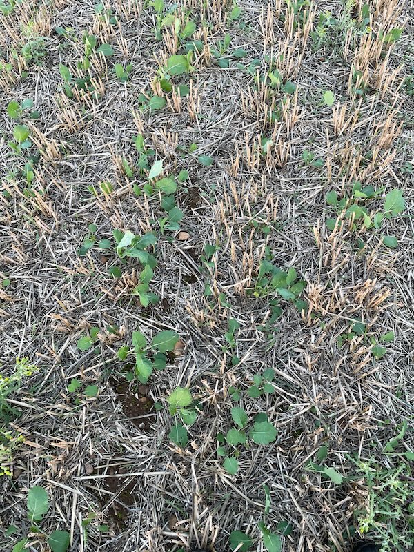
We caught up with the farms a few weeks later to check on establishment and were pleased to hear that everything had established very well and definitely equal to if not better than the previous methods, so much so that the farms have already booked us for the 2025 seeding operation.

Below are a few photos sent from the farms of the established seed, The left photo shows the turnips with the photo on the right showing the forage rape, given the dry weather establishment has been very good.

For more information on our drone seeding, spreading or spraying services please do take a look at our dedicated website page here or for more pictures of work we’ve completed our Instagram page is a great gallery

Farm Boundary Mapping By Drone

Farm Boundary Mapping By Drone

Transforming Farm Boundary Mapping with SAS Land Services Drones

Accurate farm boundary mapping is a critical component of effective land management. It ensures that farmers have a precise understanding of their property limits, aids in the resolution of disputes, and supports various aspects of farm planning and management. Traditionally, mapping farm boundaries has been a labor-intensive and time-consuming process, often requiring the services of surveyors using ground-based methods. However, advancements in drone technology, particularly the services offered by companies like SAS Land Services, are revolutionizing this essential aspect of farming.
 
Why Farm Boundary Mapping Matters
 
Understanding and accurately mapping the boundaries of a farm is vital for several reasons:
 
1.Legal Clarity: Accurate maps ensure that landowners know the exact limits of their property, which is crucial for legal purposes. This clarity helps in avoiding disputes with neighboring properties and ensures compliance with regulations.
2.Land Management: Detailed boundary maps assist in efficient land management, including planning for crop rotation, pasture management, and the installation of fencing and other infrastructure.
3.Grant and Subsidy Applications: Many government grants and agricultural subsidies require precise land measurements. Accurate mapping is essential for applying for these financial supports.
4.Environmental Planning: Understanding the exact boundaries of a farm is also important for environmental management, including the protection of natural resources and compliance with conservation regulations.
 
SAS Land Services: Precision Mapping with Drones
 
SAS Land Services is at the forefront of utilizing drone technology for farm boundary mapping. Their approach leverages the latest advancements in drone-based surveying to provide farmers with highly accurate and detailed maps of their land. Here’s how SAS Land Services is transforming farm boundary mapping:
 
1.High-Resolution Aerial Imagery
SAS Land Services uses drones equipped with high-resolution cameras to capture detailed aerial images of farm properties. These images provide a bird’s-eye view of the land, allowing for the identification of precise boundary lines and the detection of any features that may affect boundary placement, such as hedgerows, rivers, or fences.
2.Advanced Geospatial Technology
The drones used by SAS Land Services are not just equipped with cameras; they are integrated with advanced geospatial technology, including GPS and GIS (Geographic Information Systems). This allows for the creation of highly accurate maps that can be used for legal documentation, planning, and other purposes. The data captured by drones is processed to create maps that reflect the true contours and features of the land, down to a centimeter-level accuracy.
3.Efficiency and Speed
Traditional boundary mapping methods often require multiple days of on-site work, followed by extensive data processing. In contrast, SAS Land Services’ drones can survey large areas in a fraction of the time. The data is then quickly processed using sophisticated software, providing farmers with accurate maps in a matter of hours or days, rather than weeks.
4.Cost-Effective Solutions
By utilizing drone technology, SAS Land Services offers a cost-effective alternative to traditional surveying methods. The reduced time and labor involved in drone-based mapping translate into lower costs for farmers, making it an attractive option for both small and large-scale operations.
5.Versatility and Accessibility
One of the major advantages of using drones for boundary mapping is their ability to access areas that are difficult to reach with traditional surveying equipment. This is particularly beneficial for farms with rugged terrain, dense vegetation, or areas that are otherwise inaccessible. Drones can easily fly over obstacles, ensuring that every part of the farm is accurately mapped.
 
Applications Beyond Boundary Mapping
 
While farm boundary mapping is a primary service offered by SAS Land Services, the technology also supports a wide range of other agricultural applications. These include:
 
•Crop Health Monitoring: Beyond mapping boundaries, drones can be used to monitor crop health across the farm, identifying areas that require attention.
•Irrigation Planning: Accurate maps assist in the design of efficient irrigation systems, ensuring optimal water distribution across the farm.
•Infrastructure Planning: Detailed maps help in planning the placement of infrastructure such as fencing, barns, and access roads.
 
The Future of Farm Mapping with SAS Land Services
 
As drone technology continues to advance, the capabilities of SAS Land Services are likely to expand even further. Future developments may include enhanced imaging technologies, real-time data processing, and integration with other precision farming tools. This will provide farmers with even more detailed insights into their land, helping them to manage their farms more effectively and sustainably.
 
Conclusion
 
SAS Land Services is pioneering the use of drone technology for farm boundary mapping, offering farmers a faster, more accurate, and cost-effective solution to this essential task. By providing high-resolution aerial imagery, precise geospatial data, and efficient service, they are helping farmers across the UK gain a clearer understanding of their land, leading to better management and planning. As the agriculture industry continues to embrace technology, services like those offered by SAS Land Services are set to play a crucial role in the future of farming.

SAS Land Services Ltd: Pioneering Drone Technology in the UK with DJI Agras T50

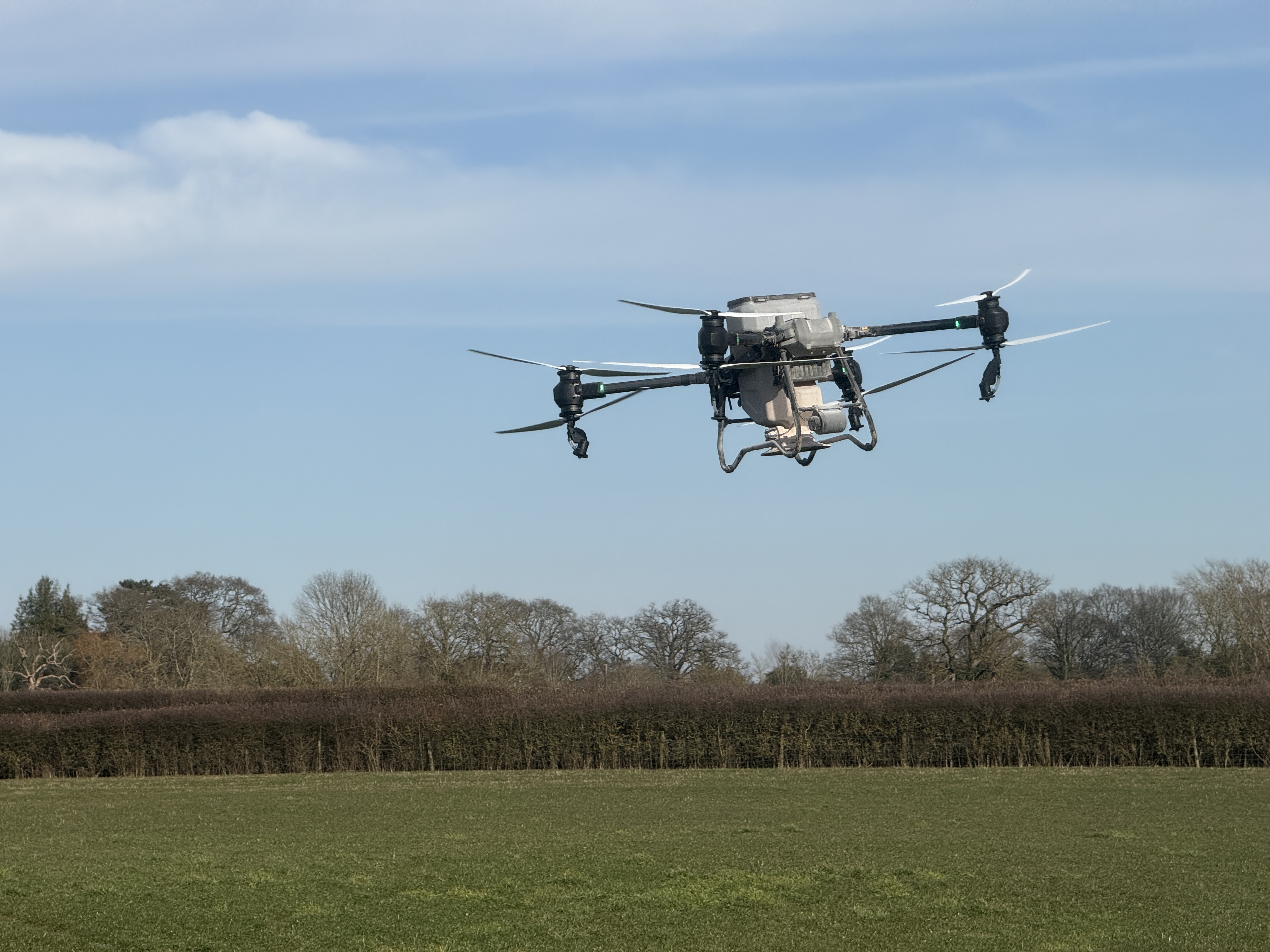
In a groundbreaking development for the UK’s agricultural sector, SAS Land Services Ltd has become the first company in the country to gain official authorisation to operate the DJI Agras T50 spray drone. This milestone not only marks a significant achievement for SAS Land Services Ltd but also represents a turning point in the adoption of advanced drone technology within the UK’s farming industry.

A New Era in Precision Agriculture

The DJI Agras T50 is at the cutting edge of agricultural drone technology, designed to provide precise and efficient crop spraying solutions. With its high payload capacity, advanced spraying systems, and intelligent flight control, the T50 is engineered to meet the rigorous demands of modern farming. It offers unparalleled precision in the application of pesticides, fertilizers, and other crop treatments, reducing waste and ensuring uniform coverage.

The drone’s intelligent system is capable of adjusting spray parameters in real-time, responding to variations in terrain and crop type. This not only improves the efficacy of spraying but also minimizes the environmental impact, making it an ideal solution for sustainable farming practices.

Regulatory Approval: A First for the UK

Securing authorisation to operate a drone of this capability is no small feat, especially in the UK, where regulations around drone usage are stringent. The Civil Aviation Authority (CAA) has a rigorous process for granting permissions, especially for commercial operations involving larger drones like the DJI Agras T50.

SAS Land Services Ltd has successfully navigated this complex regulatory landscape, demonstrating not only the technical capabilities of the DJI Agras T50 but also their own commitment to safe and responsible drone operation. The company’s achievement sets a precedent for others in the agricultural sector, paving the way for broader adoption of drone technology in the UK.

Transforming Agriculture with Drone Technology

The authorisation of the DJI Agras T50 is a game-changer for SAS Land Services Ltd and the wider farming community. By integrating this advanced drone into their operations, SAS Land Services Ltd is poised to offer enhanced services to their clients, including more efficient crop management and improved yield outcomes.

The use of drones like the DJI Agras T50 allows for a level of precision and efficiency that traditional methods simply cannot match. With the ability to cover large areas quickly and accurately, drones reduce the time and labor costs associated with crop spraying. Moreover, the precise application reduces chemical runoff, promoting better environmental stewardship.

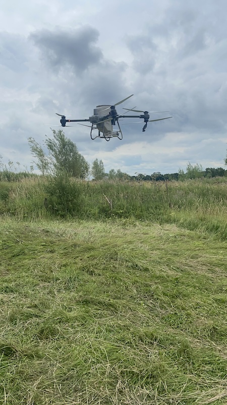
Agras T50 spray drone

Looking Ahead: The Future of Farming

As the first UK company to receive authorisation to fly the DJI Agras T50, SAS Land Services Ltd is leading the charge in modernizing the agricultural sector. Their pioneering use of drone technology is expected to inspire other companies and farmers to explore how drones can enhance their operations.

The successful deployment of the DJI Agras T50 by SAS Land Services Ltd is likely to accelerate the adoption of drone technology across the UK. This shift could lead to widespread improvements in agricultural productivity, sustainability, and innovation.

In conclusion, SAS Land Services Ltd’s achievement is not just a victory for the company but a significant advancement for the entire agricultural industry in the UK. As drone technology continues to evolve, the possibilities for its application in farming are virtually limitless, heralding a new era of precision agriculture that will benefit farmers, consumers, and the environment alike.

If you would like to know more about drone spreading, seeding or spraying, or to book us in for your work please do contact us

Drone Cover Crop Seeding

We are proud to have received authorisation from the CAA to operate large agricultural spray and spreader drones in the UK.

This allows us to drop seed, fertilisers, bio-stimulants, paints as well as other non regulated products.

Because of the ability to spread seeds from the air using a drone we have been very busy spreading cover crop seeds as well as companion cropping mixes, grass and turnip seeds all from the drone without any damage to crops nearing harvest readiness.

As well as reducing damage to standing crops seeding by drone allows faster speeds than could be achieved by driving across the field and is highly accurate. using RTK corrections for superior GPS accuracy.

If you would like to have crops seeded by drone please contact us

Revolutionizing Land Management with Spray Drone Services from SAS Land Services in Berkshire

In the heart of Berkshire, SAS Land Services is at the forefront of innovation in land management, offering cutting-edge spray drone services. This advanced technology is transforming how agricultural and environmental tasks are carried out, providing efficient, precise, and environmentally friendly solutions.

The Future of Land Management

Drones have rapidly become a game-changer in various industries, and land management is no exception. SAS Land Services utilizes state-of-the-art spray drones to deliver top-notch service, ensuring optimal results for a variety of applications, including agriculture, forestry, and conservation efforts.

Benefits of Spray Drone Services

  1. Precision and Accuracy
  • Spray drones offer unparalleled precision, ensuring that pesticides, herbicides, and fertilizers are applied exactly where needed. This targeted approach minimizes waste and maximizes effectiveness, leading to healthier crops and plants.
  1. Efficiency and Speed
  • Traditional spraying methods can be time-consuming and labor-intensive. Spray drones can cover large areas quickly and efficiently, reducing the time and manpower required for land management tasks.
  1. Environmental Sustainability
  • With precise application, spray drones help reduce the overall amount of chemicals used, mitigating their impact on the environment. This sustainable approach supports the health of local ecosystems and promotes biodiversity.
  1. Accessibility
  • Drones can easily access hard-to-reach areas, such as steep terrains, dense forests, or wetlands, where traditional equipment might struggle. This capability ensures comprehensive coverage of all land areas.
  1. Cost-Effective
  • By reducing the need for manual labor and optimizing the use of resources, spray drone services can significantly lower operational costs. This cost-effectiveness makes advanced land management accessible to more landowners and farmers.

Applications of Spray Drone Services

  1. Agriculture
  • From crop spraying to monitoring plant health, spray drones provide farmers with the tools to enhance productivity and crop yields. They enable precise application of fertilizers and pesticides, ensuring that crops receive the care they need to thrive.
  1. Forestry
  • In forestry management, drones can be used for tasks such as reforestation, pest control, and monitoring tree health. They help maintain the health and sustainability of forested areas, supporting conservation efforts.
  1. Environmental Management
  • Spray drones play a crucial role in managing invasive species, restoring natural habitats, and maintaining green spaces. Their ability to reach inaccessible areas ensures that all parts of an ecosystem are cared for.

Why Choose SAS Land Services?

SAS Land Services is committed to delivering high-quality, innovative solutions tailored to the unique needs of our clients. Our team of experienced professionals uses the latest drone technology to provide efficient and effective land management services. With a focus on sustainability, precision, and customer satisfaction, SAS Land Services stands out as a leader in the industry.

Get in Touch

Ready to revolutionize your land management practices? Contact SAS Land Services today to learn more about our spray drone services and how they can benefit your property.

📞 Call us at: 01344 534089
📧 Email: steve@saslandservices.com
🌐 Visit: saslandservices.com

Stay ahead of the curve with SAS Land Services – where innovation meets excellence in land management.


By leveraging the power of spray drone technology, SAS Land Services is setting new standards in the industry. Whether you’re a farmer, a forester, or a conservationist, our advanced services offer a smarter, more sustainable way to manage your land. Embrace the future of land management with SAS Land Services in Berkshire.

Spot Spraying Map

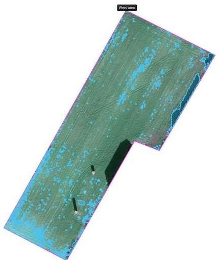
We were asked by a local farmer who farms land within a SSSI area if we could use our drone to find and mark weeds for spot spraying using the farms own equipment, the answer was yes, of course we can!

Our drone imagery is of such a high quality that we can use our software and AI intelligence to locate, mark and then create a spot spraying map for all the areas where weed is located. This is then exported and sent to the tractor and sprayer and controls the sprayer nozzles through the existing ISOBUS terminal.

By utilising spot spraying and variable rate applications means only the areas needing treatment are sprayed, this results in large savings of chemical which in turn saves money. It also means that areas not requiring treatment are not sprayed and any wildlife or habitats are not harmed, it also means the run off risk is reduced or eliminated benefitting watercourses and fish.

The flights are easy to complete subject to weather and doesn’t require us to walk across the fields (unless we need to, to stay within VLOS range of the drone!)

Spot spraying maps will be an everyday part of farming in the future with more targeted applications, we are here to assist you in getting these maps produced and into your equipment.

The costs of the flights are usually more than covered through the cost savings generated through reduced chemical usage.

Contact us to find out more or book a survey for your own farm.

Follow us On Facebook to see more of what we get up to.

Agricultural Drone Crop Services and Drone Fertiliser Spreading

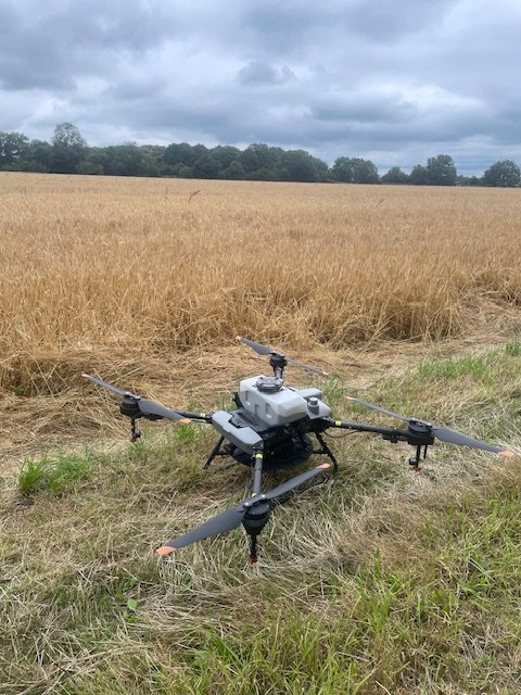
We have been busy working away over the last few months to get our CAA approval to provide agricultural drone services.

Multispectral image of field

We now offer crop mapping and analysis services using both a multispectral drone or a crop scouting service by drone, using drones for agricultural crop mapping, scouting and analysis saves time and man hours as well as provides multiple insights into how the crop is doing, any pests, diseases or water problems as well as variable rate prescription maps for tractors, sprayers and fertiliser spreaders.

We will also be offering a variable rate fertiliser or seeding service using modern agricultural spray drones across Berkshire, Hampshire, Surrey, Sussex, Oxfordshire, Gloucestershire, Wiltshire and Herefordshire.

Spray Drone

All of our agricultural drone services are offered across Berkshire, Hampshire, Surrey, Sussex, Oxfordshire, Gloucestershire, Wiltshire and Herefordshire.

Using drones can achieve savings across crop inputs as well as spot early signs of disease or pests, and in much less time than doing a similar job manually.

This means crops can be analysed more often and the inputs adjusted accordingly.

Contact us for more information or to see how we can help you save money on inputs and make better use of your crops.